In 2006, the Norwegian government endorsed a plan for ‘Integrated Management of the Marine Environment of the Barents Sea and the sea areas off the Lofoten Islands’. A similar plan for the Norwegian Sea was endorsed by the parliament in 2009.
These management plans provide the political basis for managing these important sea areas. The areas include a variety of vulnerable habitats as well as valuable marine living resources and petroleum resources. Indicators with reference values and action thresholds have been developed. Extensive coordinated monitoring will ensure a scientific base for management according to the defined action thresholds.
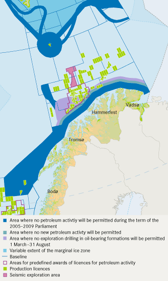
The management plans give the overall framework for both existing and new activities and facilitate co-existence between different sectors, in particular the fisheries, maritime transport and the offshore petroleum industry. Spatial planning is a core element in the integrated management plans. In order to reduce potential conflicts between activities and the protection of vulnerable habitats and species, special restrictions are set for the use of geographically defined areas and zones. These include areas and zones with restrictions on petroleum activities (see figure), mandatory shipping lanes, and areas with coral reefs where fishing with gear able to harm the corals is prohibited. The management plans will be rolling plans and will be updated at regular intervals. The Barents Sea plan will be revised in 2010.


